A reminder of the 2 halves of the Baja 14 concessi
Post# of 8059

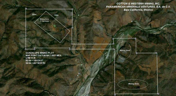
A reminder of the 2 halves of the Baja 14 concession-as noted on this graphic the current mine is the North 1/2 here shown on left side of graphic-I call it North-which it is- because I have seen graphics much more clearly detailing that than in this one
Not sure what the 2 "mining area"s are on south half-south of that broad often dry swale known as San Vicente River (and locals often have different names for these things which is confusing) because they havent started mining South half yet -they have to our knowledge only done preliminary exploration work on S 1/2 of concession.
The narrow strip connecting the 2 halves is 200 ft wide from what I've read. They added land to the concession ca Sept 2011-see Sept 2011 PR apparently along the strike length of the Coloso vein-either the left side here or the right side-where the other mine was -which closed up shop because that other mine couldnt succeed-and so CWRN may have acquired some of that property near the 200 ft wide connecting corridor in the direction of the Coloso and Samson strike.
All the ore mined so far has come from just a very small part of the N1/2 where the green arrow is pointing-if they have anywhere near the ore indicated by holes 69-73 (which indicated 13,400,000 tons in that little rectangle alone as per CWRN-and they didnt mine to the end of the iron in any of those holes- see bingo's postings and April 13,2012 and Sept 2011 PR's etc) in the rest of the Coloso or Samson veins they could mine those veins for many years at a Panamax /month.
copyright Pan Am or CWRN from website-Max also has these graphics in his excellent dd summary.

 (0)
(0) (0)
(0)