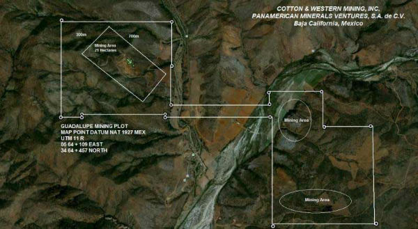
U can cf w this graphic whose orientation has alwa
Post# of 8059
map convention is top is N, bottom is S, left is W, but other graphics I've seen and angle of sun etc indicate hwy borders CWRN to W -but this shows hwy bordering on E-I always thought the failed mine across the hwy was to W but here shows to E- the flat field somebody thought was storing iron followed by very steep incline we've seen in pics
[although the haves of the mine are called N and S,which is correct here ,it would be more proper to call W and E as u can see-another piece of conflicting info if the orientation on this thing is correct
so i correct myself-if the orientation of this graphic is correct and has not been flipped the hwy along the border is to the E of mine,so would have to post new topo iron coloring graphic
the bordering KMG Navial activity we've seen in pics is apparently to S [of Baja 14 N] because said pic shows the San Vicente R eerily coming out of the mountains towards the KMG activity-I only say KMG because Madflight superimposed KMG superscript over said pic -I'll post that pic next to show u what I mean- the KMG superscript of next image is S of N1/2 of Baja 14 N according to this image
the San Vic R flows W and S to Erendira
not having been there closeup maps often dont agree w the best 1:450,000 map I have of Baja, so its a painstaking balancing process looking thru a glass darkly of 2 dimensional images w sometimes conflicting orientation -so I've had to apply seemingly conflicting info to such sometime seemingly contradictory 2 dimensional images

 (0)
(0) (0)
(0)