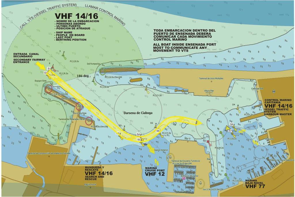
A chart of the port-the EIT (Ensenada International Terminal) is the uppermost terminal called Terminal de USOS Multiples[Multiuse terminal] here-CWRN's ore ready for shipping is usually stored directly beneath the BOAT INSIDE bold language of 2nd par at top-
depth figures in nautical charts are normally in fathoms (each fathom is 6 feet w the 2nd figure in USA representing feet)-I've read a lot of nautical charts and have never seen the pattern of depth readings shown here but I now see the first figure -rather than fathoms is apparently meters-see the circled area called Darsena de Ciabogo-which is apparently what they call the navigation area -which I know from other sources is 16 meters deep-and since they show 16 {where normally you would have the fathom figure} that tells me these readings are in meters rather than fathoms w the second number being anybodys guess unless its fraction of a meter
this is the 1st depth chart I've seen for the port and I can now see why they didnt load directly from the previous Handymax ships own loading equipment opposite CWRN's ore when the only loading berth at the EIT was being used by another ship-and thats because that end of the terminal is not dredged as deep-as in the darker shade of blue -they-the port- were going to add a 2nd berth and set of cranes supposedly toward the end of the terminal -which would enable CWRN to load while 1st berth was used by a container but from this chart I can see they didnt even dredge for that as of the date of this chart
the chart also gives you an idea why harbor pilots are required for insurance purposes etc for the large commercial ships
this is one of many pages on port site which dont translate to english or translate only partially so I find for that and other reasons navigation of the port site frustrating- so spanish readers feel free to do dd on the port site-where I cant find the schedule of ships today

