Posted On: 11/26/2013 3:08:30 AM
Post# of 8059

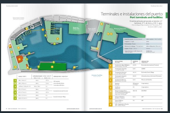
I came upon this courtesy of madflight though I had to go thru a few wormholes to present it here-- green A terminal is the EIT terminal CWRN uses 14.5 meters deep -the deepest terminal-
the darker ocean area shows deepest dredge -16 m entry corridor plus the circle turnaround navigation area, the office terminal (4) the nautical chart indicated was a delimited 8.7m is 11.7m according to this (#4) perhaps dredged to 11.7 when port dredged deeper from previous deepest 40 feet to ca 47 feet Jan 2011-
the dredger said port would then allow up to 105000 ton ships but the 80256 DWT Ilia was 13.7 m deep when loaded w only 68069 tons CWRN/Bao ore May 2013-- there is an imperfect correlation between bulker ship draft and DWT-and bulker shipowners greatly distort GRT, making it to totally uselses due to tax/license fee fraud -nullifying all the hard work that went into the GRT convention (similar to the effort to create a workable peace treaty) executed to solve these problems
Cabotage- transfer within Mexico only - (no export/import) is #1 berth- ca 12.5m deep
#3 is a fishing dock
G (API terminal) is shipyards, K is harbormaster, madflight says new mineral bulk dock at API (13.5m deep) in 2010? -but cant be for export dont think because port cant afford 2 custom terminals (only open 7 a.m. to 10 p.m as it is),which is near #2 on map (entry to export EIT terminal),where we've seen as many as 7 CWRN trucks lined up at 7 a.m. to enter export area
-then to EIT and Cabotage (1 and H area) -because this (the darker port ocean area) is the only area big bulkers enter
Cruise terminal (C) and berths (6,7) are only 9 m deep,even though cruise ships here have been up to almost 120,000 tons
B D G(ON RIGHT side) E are mostly Cemex terminal/berth but only ca 8.7m - will have to check - going by memory since cant read the numbers on stretched map
Navy dock left of Cemex -previous operator of CWRN concession to whom CWRN had been trucking to Cemex Ensenada plant for their industrial cement

